Planetary engine that can be used with real elevation data of arbitrary resolution, while being progressively enhanced by fractal algorithms. The fractal algorithms refine and introduce details down to centimeter resolution and can be parametrized by elevation and land class data. A completely random fractal terrain is possible too, or a terrain can be sketched in rough resolution with fractal generating the details. Level of detail ranges from thousands of kilometers down to centimeters, with full visibility. The engine is fully asynchronous, majority of the algorithms running on the GPU while the rest is distributed to multiple CPU cores.
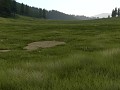


Bumpy grass effect
Post a comment
Description
Demo of bump effect on low grass
This looks sweet. What's the technique behind it? Normal mapping?
The ground looked pretty flat, till now... I'm pretty sure that many people would confuse Outerra screenshots with real photos now.
Mmmm... probably need more tree variety before that starts to happen.
crazy!
Wow, that is brilliant! Keep up the good work!
This engine already blew my mind when the ocean renderer came in. And it just keeps on getting better.
You should try this with the grass also:
I'm one of a handful of people to have used that method for rendering grass blades.
Nope, many more. :)